New paper by Steve T
One goal of the Measuring the Water Cycle research group is to improve global estimates of river discharge by utilizing remote sensing data to fill gaps in gaging networks. With currently available data, this is a hard problem: the satellite missions currently operating were not designed with rivers or lakes in mind, and as a result, it is very, very challenging to estimate river flow using currently available data.
New satellite datasets, like those anticipated from the forthcoming Surface Water and Ocean Topography (SWOT) mission, are expected to shift the fluvial remote sensing paradigm by providing high-accuracy and high-resolution data over the world’s large rivers. SWOT will generate spatially continuous measurements of the water surface elevation and extent for global rivers using Ka-band radar interferometry.
In anticipation of SWOT, a number of river discharge algorithms have been developed and tested. These algorithms have been largely designed and tested using hydraulic model data, but are largely untested on real-world remote sensing data, in large part because SWOT’s measurements are so unique!
In this study, we evaluated three SWOT discharge algorithms on data collected from AirSWOT over the Willamette River in Oregon. AirSWOT is an airborne variant of SWOT which utilizes the same radar principles as SWOT (Ka-band swath altimetry using interferometric synthetic aperture radar) and operates at a similar spatial scale.
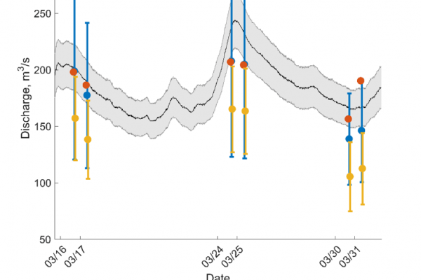
Our discharge algorithm tests using AirSWOT data constitute the first time that these discharge algorithms have been tested at the spatial scale of a SWOT reach using swath altimetry data, and our results were encouraging overall, with errors of between 10-31 % for three tested algorithms. However, in the manuscript we highlighted important caveats to our results, including a strong sensitivity to a first-guess of the flow which the algorithms use as the sole ‘a-priori’ data in a scenario where no in-situ data is available. Below, we show a hydrograph with errorbars for the three tested algorithms: MetroMan (developed at OSU by Mike), BAM (developed at UMass by Mark Hagemann, now a member of the Measuring the Water Cycle research group), and DassFlow (developed at multiple institutions in France by J. Monnier, P.A. Garambois, K. Larnier, and others). The algorithms capture the flow variability during the six AirSWOT overflights (bias-removed standard errors <10 % for all algorithms) but have substantial biases when compared with each other and the USGS gage-derived ‘true’ discharge.
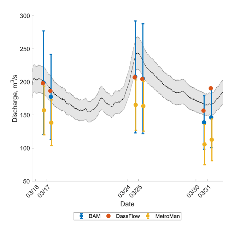
Discharge estimates for AirSWOT data, with 1 SD error bars provided for BAM and MetroMan (DassFlow does not generate a discharge uncertainty estimate). USGS data (black line) is shown with ±10% relative uncertainty (grey area).