Past Projects

Our research addresses physical and human dimensions of environmental change in glacierized landscapes. We are interested in the nature, extent and impact of changes over different scales of space and time. We incorporate different field and computer-based methods, including glacial geology and geomorphology, hydrology, meteorological monitoring, mapping with global positioning system (GPS), remote sensing, GIS and modeling. While the predominant focus is on tropical glaciers and mountain environments, we also work in mid-latitude sites once occupied by glaciers, including Great Basin National Park and Central Ohio.
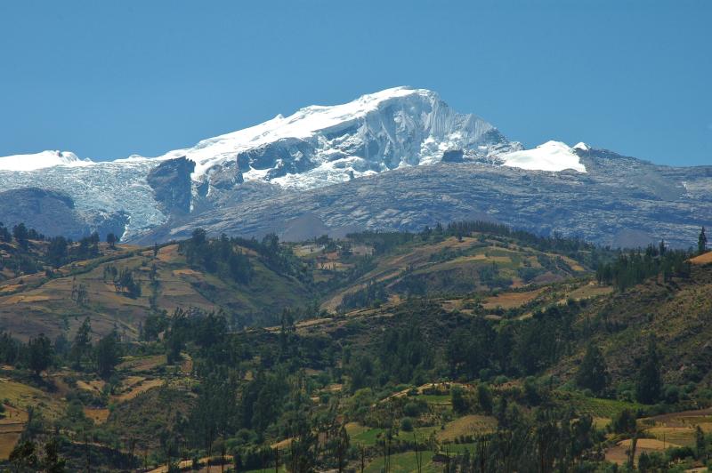
Assessing the Volume and Topographic Context of Tropical Glacier Recession
- Funding: National Aeronautics and Space Administration (NASA), National Geographic Society, CWC.
While observations of terminus retreat has shown that tropical glaciers are receding, quantifying the total volume loss remains a critical challenge to understand climate forcing and hydrological impact. Moreover, geomorphic evidence shows dramatic glacier volume changes in the past. The process and spatial extent of glacial recession is fundamentally constrained by topography, complicating the paleoclimatic interpretation of relict glacial landforms. This project utilizes state of the art surface elevation mapping (GPS, terrain analyses, aerial photography and airborne laser swath mapping) and earth observation satellite technology (including radar altimetry), in conjunction with ongoing field studies, to systematically quantify recent (late 20th century) glacier volume change in the Peruvian Andes and Kilimanjaro, Africa. We also aim to analyze the topographic context of late-glacial to modern volume change in valley-specific localities throughout the global tropics.
By now we have acquired high-resolution (submeter) digital elevation data of tropical glacier surfaces in the Cordillera Blanca, Peru, by using airborne light distance and range (LiDAR). This has allowed us to compute total volume changes in glaciers over the past ~50 years, a critical variable in assessing hydrological impact in these remote regions.
Low-latitude glacier retreat: Evidence of accelerating climate change and impacts on local to regional water resources (LLGR-ACC and WR)
- Funding: CWC
- Dates: 2006-present
The LLGR-ACC and WR core project is motivated by ever mounting scientific evidence that Earth’s globally averaged surface temperature is increasing, human activities are a key driver and Earth’s its ice cover, is responding dramatically and rapidly. Globally, glaciers are in recession and we need to better understand both the nature of this global climatic and environmental change and the impact it has on local water resources. This project has funded field work and analyses for studies in Africa (Kilimanjaro, Jan-Feb 2006) and Peru (2007-11) and has been instrumental in reconnaissance of new lines of research in Peru, Venezuela and Ecuador.
In Kilimanjaro, we have measured the total volume change in the remaining summit ice cap and glaciers, and assessed the hydrology of mountain springs and stream flow. Our results predict complete loss of the famed ice cap within decades and that large volume springs feeding agricultural irrigation projects in the Pangani basin below the mountain are fed by deep flow paths, and they are potentially recharged by older water not being replenished by seasonal precipitation. The glaciers are not an important supply of water for people currently, but their disappearance is indicative of changes not seen on the mountain for at least 11,000 years. Moreover, the older, much more extensive glaciers potentially recharged deep groundwater that is currently relied upon for consumptive use. Our collaborators have furthered understanding of human water usage and social vulnerabilities to ongoing environmental changes.
In Peru, we have advanced understanding of climate variability in the global tropics by recovering additional ice cores, and installing a distributed network of low-cost, sustainable instrumentation to monitor stream discharge and hydrometeorology. We have established collaborative work agreements with local Peruvian scientists and engineers at the National Water Authority and Geophysical Institutes that facilitate effective data acquisition and logistics. CWC funding has leveraged our other active grants to broaden and integrate results.
In Venezuela, we (led by Nathan Stansell) have attained new paleoclimate archives from lake sediments spanning the Holocene, in collaboration with colleagues at Columbia and University of Cincinnati. Preliminary results have informed new proposals to NSF.
In Ecuador, Ph.D. candidate Jeff La Frenierre is conducting dissertation research on quantifying glacier climatic changes as well as human impacts around Chimborazo. Glaciers have receded over 35% in a quarter century, and there is strong indication that locals are adapting to much lower water yields by re-routing water between natural watersheds, with implications for potential conflict. Seed funds from CWC have resulted in continued funding through U.S. Fulbright, the National Science Foundation (NSF) and the Geological Society of America (GSA), and we have established institutional affiliation with the National Meteorologic and Hydrologic Institute.
Evaluating Peruvian Glacier Recession and Livelihood Vulnerability
- Funding: National Science Foundation (NSF)
- Dates: 2008-10
Tropical Andean glaciers occupy an important nexus between physical and human dimensions of global climate change because they are both sensitive indicators of climate changes and critical hydrologic reservoirs. These glaciers exist in remote highland regions in predominantly poor, developing nations and sustained negative mass balance over recent decades has accompanied dramatic landscape changes. Our research features the use of mixed methods within the Cordillera Blanca, Peru including semi-structured interviews to evaluate the relationship between environmental changes, human vulnerability-resilience and human adaptive strategies occurring in the region. Specific research objectives include: assessing human vulnerability-resilience to increasing hydrological variability due to glacier-recession; evaluating how changing household access to resources is contributing to livelihood adaptation and change.
Over two years of fieldwork expeditions, we strategically instrumented, sampled and surveyed three case study watersheds with different percent glacierized area. As social and natural scientists, we worked to establish new standards for scientific research as our investigation required the integration of both human and physical perspectives to understand the complex nature of and relationships between environmental and social change. We have successfully completed our second and final project year examining the complex nature of and relationships between environmental and social change taking place in the world’s most glacierized tropical mountain range, the Cordillera Blanca, Peru.
The specific research objectives of the project were to:
- quantify changes in glacial volume;
- evaluate the regional impact of glacier melt on seasonal and interannual water availability and quality;
- assess human vulnerability to increasing hydrological variability due to glacier-recession; and
- evaluate how changing household access to resources is contributing to livelihood adaptation and change.
Our methodologies combined in situ observations with geospatial analyses, household surveys, key interviews, and focus groups in three representative tributary watersheds with different percent glacierization, variable hydrological characteristics and diverse livelihood pursuits. GIS and remote sensing techniques have also being utilized to integrate the human and physical components and findings of the research and extend our analyses and outreach. The project featured an innovative education program comprising graduate research, undergraduate training, public education and policy efforts and community outreach in an internationally transdisciplinary context.
Hydrologic Transformation and Human Resilience to Climate Change in the Peruvian Andes
- Funding: National Science Foundation (NSF)
- Dates: 2010-13
This project is a collaborative project involving The Ohio State University (Ohio State), University of California – Santa Cruz (UCSC), University of Oregon (UO) and University of Texas at Austin (UT). Each institution has a different but complementary focus in achieving the overall goals of the project.
The Ohio State University focuses on glacier and hydrologic transformations, maintaining hydrologic and climate instrumentation, making hydrochemical measurements, implementing hydrochemical and hydrologic modeling and integrating changes to water resources along the Santa River, Peru. We have successfully completed our first project year engaged in collaborative research on hydrologic transformations and human resilience to climate change in the Peruvian Andes.
The specific research objectives of the research are to evaluate water use, human vulnerability, land use and land cover change, watershed dynamics, water quality and water governance in the Santa River watershed in order to understand this new system of hydraulic governance that is emerging in the Andes and how glacial dynamics are transforming melt water rates as they rapidly recede. Our project also features an innovative cross-cultural education and outreach plan to increase awareness, inform policy managers, strengthen institutional partnerships and educate.
Peatlands as Carbon and Water Sinks under Warm Climates in the Susitna Basin, South-Central Alaska
- Funding: National Science Foundation (NSF)
- Dates: 2009-13
This is a collaborative project led by Zicheng Yu at Lehigh University, with fellow co-primary investigators Robert Booth and Joan Ramage. Glaciers in Alaska and elsewhere are melting due to positive albedo feedbacks and enhanced warming in high latitude (and altitude) regions. Glacier meltwater likely induces profound changes in hydrology and the functions of lowland ecosystems, especially peatlands, which play critical roles in water and carbon cycling. However, we do not know the magnitude and mechanisms of glacial meltwater impacts at a regional scale nor potential feedbacks from the resulting changes in peatland carbon and water storage.
This interdisciplinary project is to document temporal and spatial changes in peatlands at a regional scale during the last 1000 years, using field monitoring, remote sensing and paleoecological techniques in paired glacierized and non-glacierized watersheds of the Susitna Basin. The insights gained from this study will be applicable to other regions in Alaska and other high latitude regions that have experienced similar climate, hydrological and ecological changes. The results of this project will provide valuable insights into understanding the connections of climate, glacier dynamics, hydrology and ecosystems in a changing world.
Simulating Tropical Paleoglaciers
Tropical glaciers are sensitive indicators of high-elevation, low-latitude climate dynamics on various timescales. Abandoned moraines of the last ice age have long been recognized as evidence of the warming that attended the close of that period. Advances in field mapping, remote sensing and geospatial data processing offer opportunities to refine the spatial and temporal precision of the geologic record of past glacier changes, but there remains a lack of modeling techniques suitable for testing climate hypotheses about observed glacier changes. Glacier changes during the Last Glacial Maximum (LGM) are of particular interest because reconciling relatively large tropical LGM snowline depressions with paleoclimatic proxies that indicate only minor tropical sea surface temperature changes has presented a problem for climate scientists. This collaborative and interdisciplinary project will provide refined LGM paleoclimate estimates for key tropical mountain areas. A 2-D (map view) coupled glacier mass balance and glacier flow model will be specifically adapted to tropical conditions. High-quality-controlled meteorological observations and digital elevation models (DEMs) will drive the model in order to reconstruct LGM glacier extents mapped using field and remote sensing methods for a feasible number of sites having well-established chronologies.
Assessment of Late Holocene and 21st Century Climate in Great Basin National Park, Nevada
- Funding: Western National Parks Association and Department of Geography, The Ohio State University
- Dates: 2005-present
The ongoing Great Basin National Park (GBNP) project aims to assess climate on a variety of different time scales and across environmental disciplines. Sediment cores retrieved from alpine lakes provide an indicator of aquatic health and the corresponding climate for at least the last 2000 years. The midge communities in the lakes underwent little compositional change through much of the 20th century; however, after 1980 a rapid lake-specific faunal turnover was observed. To understand present climate and allow for projections for the future, hydroclimatic and surface observations are being maintained. Contaminants and heavy metals are measured in water samples collected annually from the park’s springs, streams and lakes. An embedded sensor network of over 30 instruments measures hourly air temperatures and humidity values. Complementing the embedded sensor network are water temperature measurements at several locations. Together, they provide local snapshots of the diurnal and seasonal cycles. As the embedded sensor network matures, the data may be used in the calibration of models applied to future climate and aquatic projections. An equally important benefit of the GBNP project is the continued training of undergraduate and graduate students in field methods.