Greenland Mapping Project (GIMP) 2000 Imagery Mosaic

Description
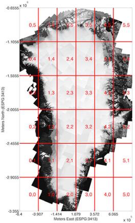
This is mosaiced Landsat ETM+ and RADARSAT imagery from the years 1999 to 2002, distributed as 8-bit geotiffs in the tiles shown. For each tile there is one image for each band, plus an index image in which each pixel gives the index number of its corresponding source image in an accompanying metadata file. The metadata file lists each Landsat scene identification number (scene ID) used in the mosaic for that tile, the acquisition time, and the root-mean-square control point registration error where available. The original scene ID, acquisition date and geo-location error for any pixel in an image can thus be obtained using the index image. Please see the paper referenced below for more information about these data.
Data now available from the NSIDC
Supporting Software
Coming soon!
Data Citation
Howat, I.M., A. Negrete, B.E. Smith, 2014, The Greenland Ice Mapping Project (GIMP) land classification and surface elevation datasets, The Cryosphere, 8, 1509-1518, doi:10.5194/tc-8-1509-2014 abstract | article [pdf]
[pdf] - Some links on this page are to Adobe .pdf files requiring the use of Adobe Reader. If you need these files in a more accessible format, please contact howat.4@osu.edu.
