Human-Made Contaminants
Investigating mechanisms and pathways for the transport of particle-reactive contaminants in Eurasian arctic seas
This project focused primarily on tracking the plutonium tracer signal emanating from the former nuclear test site of Chernaya Bay, located on the southern coastline of the island of Novaya Zemlya, southern Barents Sea off the northern coats of Norway and Russia. The large (11 TBq) inventory of plutonium in Chernaya Bay, derived from underwater nuclear tests in the 1950s, is characterized by low 241Am/239,240Pu activity ratios of 0.05 and 240Pu/239Pu atom ratios of 0.03 ( Smith et al., 2000) compared to fallout background ratios of 0.35 and 0.18, respectively, that prevail throughout most of the world oceans. It has recently been established that surficial sediments in the Makarov and Eurasian Basins of the Arctic Ocean have similarly low 241Am/239,240Pu and 240Pu/239Pu ratios (Huh et al., 1998) and it is hypothesized that a significant component of this plutonium is the result of long-range transport from Chernaya Bay. The results of this study provide a framework for assessing the potential transport of radionuclides from the southern Barents Sea into deep basins of the Arctic Ocean. More generally, these results provide a basis for the prediction of particle-reactive contaminant transport into the Arctic Ocean from a wide range of urban and industrial sources located along the Eurasian arctic coast.
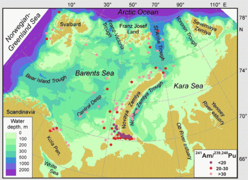
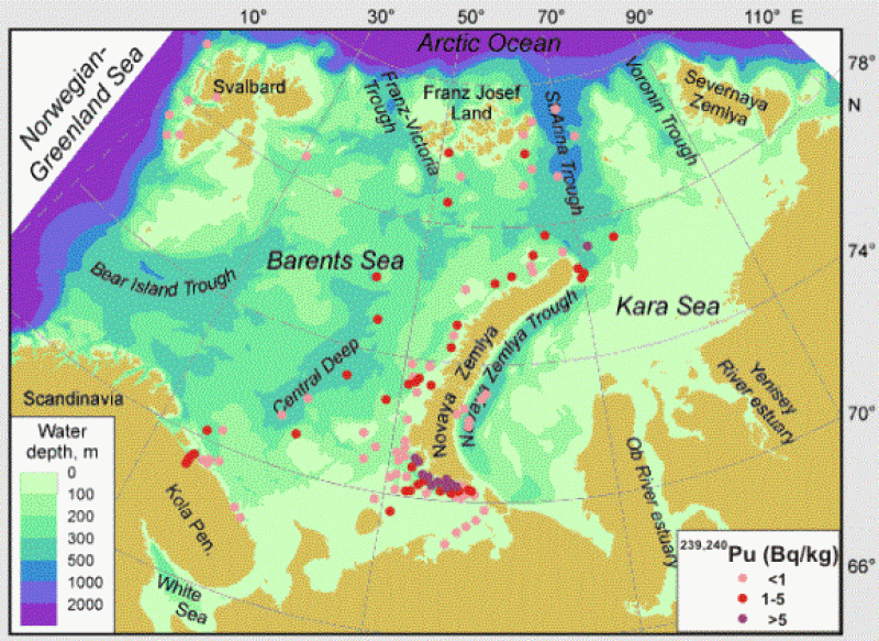
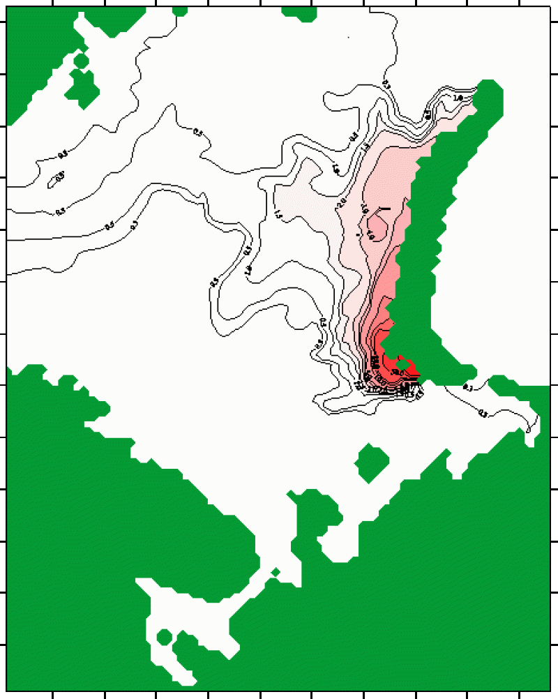
Sediments from a combination of newly collected and archived grab samples, box and gravity cores from the Kara and Barents Seas and the basins of the Arctic Ocean are analyzed for radionuclides (210Pb, 137Cs, 60Co, 241Am, 239Pu, 240Pu) and metals as part of this study. Geochemical and radionuclide analyses are performed at the Bedford Institute of Oceanography under the supervision of J.N.Smith; additionally, ICP-MS plutonium isotopic composition is measured by S.B.Moran at the Graduate School of Oceanography, University of Rhode Island. The surface sediment distribution of 239,240Pu and 241Am/239,240Pu ratio is illustrated in Figures 1 and 2 ( data provided in Table 1). The highest plutonium activity and lowest 241Am/239,240Pu levels are clearly focused at the southern coast of Novaya Zemlya. The influence of Chernaya Bay discharges decreases rapidly with distance southward, but extends for much greater distances (more than 100 kilometers) north-westward along the Novaya Zemlya coastline, which is consistent with prevailing circulation patterns. This was further tested by hydrodynamic modeling of tracer propagation from Chernaya Bay in bottom waters (Fig. 3). The modeling results indicate predominant tracer transport northwards along the western coast of Novaya Zemlya, with a westward branch into the central Barents Sea. This pattern appears to be in agreement with regions of elevated 239,240Pu sediment activities and low 241Am/239,240Pu levels along the western and northern coasts of Novaya Zemlya (Figs. 1-2). However, the sampling coverage is insufficient to definitively map an imprint of a plutonium plume emanating from Chernaya Bay that would indicate transport as far north as the St. Anna Trough and the Arctic Ocean.
Results
Current results indicate that the transport of particle-reactive contaminants from Chernaya Bay is mostly confined to regions within about 150 km of the site of the nuclear tests at the southern coast of Novaya Zemlya. It may also be generally concluded that the transport of particle reactive contaminants from other sources of pollution along the Eurasian arctic coastline will be similarly restricted to shelf and slope waters proximal to river mouths or the location of contaminant discharge sites. The most recent sampling expedition was carried out in 2002 on an axis lying directly across the predicted path for the transport of Chernaya Bay tracer at a distance sufficiently close to Chernaya Bay (~200 kilometers) to clearly delineate the shape of the plume. The present ongoing analyses of these samples will provide a clearer answer to the ultimate fate of the large inventory of plutonium swept into the Barents Sea from nuclear tests in Chernaya Bay.

Figure 1. Distribution of 239,240Pu concentrations in surface sediments of the Barents Sea.

Figure 2. Distribution of 241Am/239,240Pu levels in surface sediments of the Barents Sea.

Figure 3. Modeled distribution of tracer from Chernaya Bay (in %) in bottom water of the Barents Sea after 15 months. Numeric modeling was performed by M. Kulakov and V. Stanovoy based on the S-Coordinate Rutgers University Model (SCRUM). BARCODE Atlas was used for initial hydrographic conditions.
Results obtained in connection with this project characterize other potential sources of contaminants in the Barents Sea, such as the Kola Bay (Smith et al., 1999 and in prep.) and the sunken submarine “Kursk” (Matishov et al., 2002).
Support and Funding
This project was supported by the National Science Foundation award OPP-9908871 to L. Polyak. Collaborating Russian institutions include Research Institute for Ocean Geology (VNII Okeangeologia), Arctic and Antarctic Research Institute (AARI), and Murmansk Marine Biological Institute (MMBI).
Related Publications
- Smith, J.N., Ellis, K.M., Polyak, L., Ivanov, G., Forman, S.L., Moran, S.B., 2000. 239,240Pu transport into the Arctic Ocean from underwater nuclear tests in Chernaya Bay, Novaya Zemlya. Cont. Shelf Research 20, 255-279.
- Smith, J.N., Polyak, L.V., Vanshtein, B.G., Rahmanov, A.E., Vishnyakov, I.A., 1999. Technogenous radionuclides in bottom deposits of Kola Bay. In: Geology of seas and oceans. XIII Internat. Seminar in Marine Geology, Moscow, Abstract Vol. 2, 33-34.
- Matishov, G.G., Matishov, D.G., Namjatov, A.E., Smith, J.N., Carroll, J., Dahle, S., 2002. Radioactivity near the sunken submarine “Kursk” in the southern Barents Sea. Environ. Sci. Technol. 36, 1919-1922.
