Understanding Urban Warming in Rajshahi City Through Thermal Remote Sensing and Geospatial Analysis
A recent study published in Sustainability explores the patterns and causes of wintertime urban warming in Rajshahi City, Bangladesh. The study was co-authored by Dr. Md Rejaur Rahman of the University of Rajshahi, Bangladesh, who is currently a Fulbright Visiting Research Scholar working with Professor Bryan Mark in the Department of Geography at The Ohio State University. Professor Mark is the principal investigator of the Glacier Environmental Change Research Group at the Byrd Polar and Climate Research Center.
Using remote sensing and GIS technologies, the researchers examined how land surface temperature (LST) has changed over 33 years, from 1990 to 2023, and how these changes relate to the city's physical landscape.
The study found that winter LST in Rajshahi has increased by an average of 2.66 °C, with some areas experiencing a rise of more than 4 °C. These temperature increases are most prominent in central and rapidly urbanizing parts of the city, where buildings, roads, and other impervious surfaces have replaced vegetation and water bodies. The research team identified these trends using satellite imagery from Landsat missions, calculating several biophysical indices, such as the vegetation index and built-up area index, to measure changes in land use and land cover (LULC).
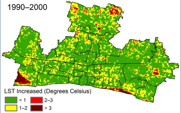
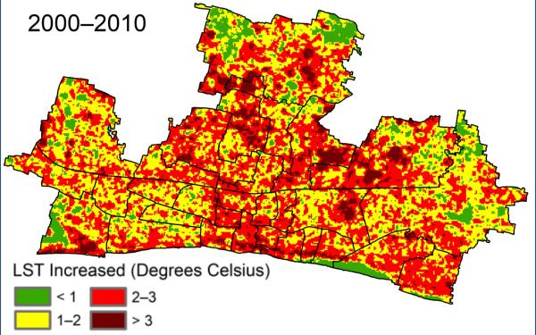
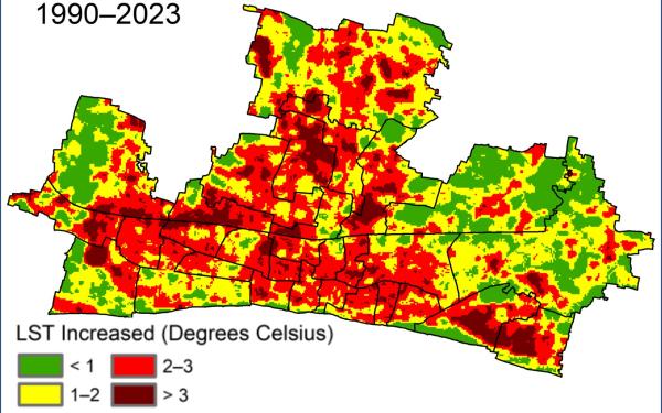
Figure: Spatial pattern of land surface temperature (LST) increase.
One of the study's key findings was the strong relationship between increased temperatures and urban expansion. Areas with dense development showed the highest temperatures, while zones with more vegetation and water experienced lower LST values. These patterns were confirmed using various spatial analyses, including the Urban Thermal Field Variance Index (UTFVI) and hotspot mapping, which helped to identify heat-prone zones and areas under ecological stress.
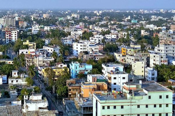
Rajshahi City, with a population nearing one million, has seen significant urban growth in recent decades, which has resulted in substantial changes to the natural landscape and local climate. The researchers stress that winter warming, often overlooked in tropical cities, can disrupt ecosystems, reduce thermal comfort, and contribute to year-round challenges such as increased pest activity and decreased urban biodiversity.
The study advocates for more climate-sensitive urban planning. Recommendations include expanding green infrastructure, preserving surface water features, and using more permeable construction materials. These strategies could help mitigate the effects of urban heat islands and promote sustainable growth.
This research offers a transferable analytical framework that other rapidly developing cities can use to understand and respond to urban warming. By highlighting the urgent need for adaptive planning, the study contributes to broader efforts to enhance urban resilience in the face of climate change.
The study, published in Sustainability, is titled "Geospatial analysis of urban warming: A remote sensing and GIS-based investigation of winter land surface temperature and biophysical composition in Rajshahi City, Bangladesh."