Climate Change Intensifies Risk of Devastating Floods in Sikkim Himalaya
A recent study published in the journal Remote Sensing Applications: Society and Environment, led by the Byrd Center's Postdoctoral Scholar Saurabh Kaushik highlights the increasing threat of Glacial Lake Outburst Floods (GLOFs) in the Sikkim region of the Eastern Himalaya. The research reveals that climate change significantly exacerbates the risk of these potentially catastrophic events, posing a serious danger to local communities and infrastructure.
The study, conducted by a team of international researchers, updated the inventory of glacial lakes in the Sikkim Himalaya, identifying 232 lakes covering an area of over 22 square kilometers. Using advanced mapping techniques, the team assessed the risk levels of these lakes, discovering that Khanchung Lake is the most dangerous, with potential peak discharges of up to 9504 cubic meters per second in extreme scenarios. South Lhonak Lake also poses a high risk, with peak discharges estimated at 8421 cubic meters per second.
Location map of Sikkim
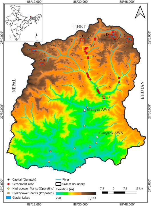
The increasing number and size of glacial lakes due to climate change significantly heighten the risk of outburst floods. The study's simulations indicate that even the least dangerous lake, Yongdi Lake, could cause significant flooding, with potential discharges affecting the town of Chungthang. The research highlights the imminent threat to approximately 1900 settlements, five bridges, and two hydropower plants in the region.
The data generated from this study provide critical insights that can help local authorities implement effective strategies to mitigate the impact of GLOFs. The study calls for early warning systems and measures to prevent breaches in the most hazardous lakes.