Layer cake snow stratigraphy
A bunch of us (me, Ben, Jinmei, Melissa, and Rhae Sung) just got back from participating in a field course led by Noah Molotch (UC Boulder). We were hosted by Storm Peak Lab (SPL); SPL is directed by Gannet Hallar & Ian McCubbin. Great time.
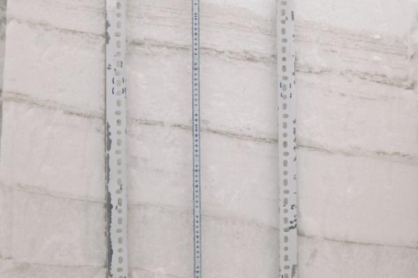
It was the first time out for the new OSU snow radiometers, which went really well. This photo documents the snow stratigraphy from a windswept area near the top of the mountain, near SPL (elevation 3220 m, ~10,500 ft). The photograph was taken with a filter that only allows near infrared wavelengths, rather than visible; this highlights differences in snow texture, grain size, stratigraphy, and density. Ice crusts form the denser layers, which appear darker. The lower layers were loose depth hoar snow; the upper light-colored layer was fresh snow that had fallen the day prior to when the photograph was taken. The overall “layer cake” appearance in this photo shows snowfall events separated by ice crusts, formed during warm weather events. This is unusual for this time of year at this elevation and location, and highlights the warmer weather the area has experienced. Normally, the different snow layers would be distinguishable, but without the darker ice layers separating them out.
These layers affect how this area looks to satellite measurements — studies have shown that these kind of effects are important to resolve in interpreting imagery.
The layer from 80-92 cm consisted of many ~1 mm ice lenses formed by melt during the day, and was crazy hard to get a shovel through: you needed a pick axe, just about. From 16-37 cm was all sugar.
Photo by Alice Hill of CU, on our group’s Nikon D7000 with NIR filter by MaxMax.