Reconstructing the Quelccaya Ice Cap's Holocene Evolution Through Radiocarbon-Dated Plant Remains
The Quelccaya Ice Cap (QIC) in Peru, recognized as one of the world's largest tropical ice caps, has been the focus of extensive research, particularly in studying its fluctuations during the Holocene. A recent study at The Ohio State University has implemented the radiocarbon dating of rooted plant samples collected directly from the ice cap's western edge along with a suite of other paleoclimatic data to understand its extent throughout the Holocene.
This research, led by Byrd Center member and School of Earth Sciences Ph.D. candidate Kara Lamantia, aimed at forming a more cohesive historical understanding of the ice cap's western extent throughout the Holocene, with the collected plant samples providing brand new data into a previously unknown gap in time. The analysis of these plant samples indicated that between approximately 7.1 and 4.5 thousand years ago (ka BP), the QIC expanded roughly 350 meters into the western Challpacocha Valley. Typically, advancing ice would eradicate vegetation and soil in a valley, but here, the plants remained in their growth positions, and the radiocarbon dating uncovered this now-documented ice-margin advance.
Additionally, further evidence from surrounding valleys indicates that the QIC's fluctuations in response to Holocene climate changes were consistent with the patterns observed in the Challpacocha Valley. The plant data was integrated with various studies involving records from ice cores, lacustrine sediment cores, and glacial moraine deposits to understand the QIC's historical behavior better. These gathered records are coupled with other proxy evidence and point to a considerable climatic shift occurring between 5 and 7 ka BP, which likely contributed to the expansion of the QIC.
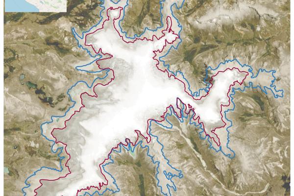
Unfortunately, the QIC's western margin has retreated in the last few decades (1985-2023) to an extent that has not been documented since at least 7,000 years ago. This retreating ice is evidenced by the exposure of the previously buried plants, which would decay in the open air after a few years if not found and collected. The retreat rates of the ice margin calculated from satellite images offer a stark indication of recent and significant climatic transformations.
The study was published in the Journal of Geophysical Research: Earth Surface. In addition to Lamantia, contributing co-authors include Ice Core Paleoclimatology group members.
This research relied on previous field expeditions' work as well as the work of other researchers and collaborators using grants from NSF, NOAA, OSU, and donations from Byrd Center Ice Core Salvage Fund.
To read about the study, visit JGR: Earth Surface or download the PDF.
The research was also published in the January edition of AGU's EOS as an Editor's Highlight.
Image detail: The satellite image to the right is of the Quelccaya Ice Cap, showing its retreat, with 1985 marked in blue and 2023 marked in red.