Ohio State nav bar

Study Shows Byrd Glacier's Accelerated Inland Thinning During the Genesis of the Ross Ice Shelf in Antarctica

October 16, 2023

Study Shows Byrd Glacier's Accelerated Inland Thinning During the Genesis of the Ross Ice Shelf in Antarctica

Image of snow covered ground from a plane with part of the plane in the right side of the image.

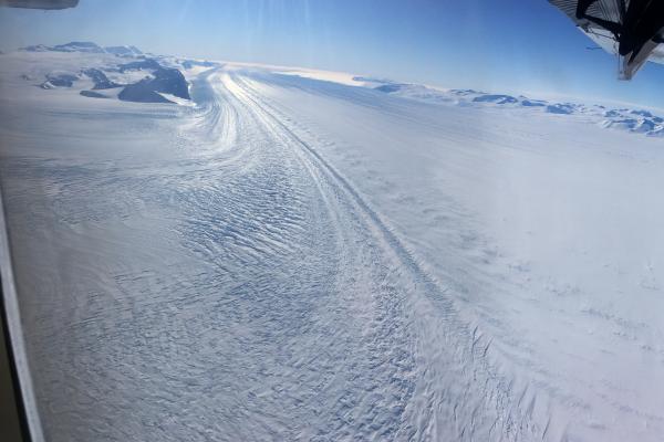
Precise dating of glacial deposits from Byrd Glacier's Lonewolf Nunataks shows that one of the world's largest glaciers thinned rapidly around 8,000 years ago as the Ross Ice Shelf formed, based on a recently published study.

A man walking toward a plane on a snow covered ground.

 With a pack full of rocks, Mountaineer Scott Barry makes his way toward the Twin Otter aircraft for departure. East Antarctic Ice Sheet and Polar Plateau in the distance, with the nearest outcrop over 1,000 miles away along the Atlantic/Indian sector of Antarctica

a brown rocky ground with a boulder in the foreground and snow covered landscape in the background.

 A glacial erratic delicately perched on bedrock records the glacial overriding and subsequent thinning of the Byrd Glacier along the Lonewolf Nunataks, the last bit of exposed rock before the expansive polar plateau

Two men in winter jackets, sunglasses and hats kneeling on the dirt ground  writing on rocks with markers

 Shaun Eaves and Jamey Stutz mark samples and record critical site information for a set of samples collected along the Lonewolf Nunataks, upper Byrd Glacier

Using surface exposure ages from glacial erratic cobbles at two sites within the Lonewolf Nunataks, researchers found the initial glacial thinning occurred at ~15 ka, with rapid thinning at ~8 ka. Ice sheet model simulations that best match the thickness constraints have faster basal sliding, but models best matching the timing have higher basal friction. This apparent change in basal sliding regime from the Last Glacial Maximum to the present may be related to the formation of the Ross Ice Shelf.

Studies like these provide critical benchmarks for numerical models to understand the future Antarctic Ice Sheet.

Snow covered ground with a  rock mountain and three people walking away from the camera. one pulling a red sled behind him

 Team K-861 make their way to the Lonewolf Nunataks to collect glacial erratics from the highest to lowest points on the mountain

This study is available online and will appear in a special issue of Earth Surface Processes and Landforms, published for the British Society for Geomorphology, an international interdisciplinary journal, to be used as a tool for understanding glacier and ice sheet behavior.

The study's principal author is Polar Rock Repository Research Scientist Jamey Stutz of The Ohio State University's Byrd Polar and Climate Research Center (Byrd Center). He conducted his research at the Antarctic Research Centre in Wellington, New Zealand, where Ohio State alumni and previous Byrd Center members Peter Webb and Peter Barrett are professors. Other co-authors included Shaun EavesKevin NortonKlaus M. WilckenClaudia MooreRob McKayDan LowryKathy Lichtand Katelyn Johnson.

Support for this research was provided by Kenn Borek Air, Antarctica New Zealand, Antarctic Research Centre, School of Geography, Earth and Environmental Sciences, Te-Herenga Waka Victoria University of Wellington, Wellington, New Zealand,  NZ Antarctic Science Platform and Australian Nuclear Science and Technology Organization (ANSTO).

Read about this study by visiting Earth Surface Processes and Landforms or download the PDF.

Photo to the right: Aerial panorama view of the upper Byrd Glacier as it flows from the high Polar Plateau down through the Byrd Fjord and joins the Ross Ice Shelf to discharge into the Southern Ocean. For scale, the Byrd Fjord is approximately 15 miles wide

News Filters: