The Vanishing Peruvian Andes Ice Cap: Preserving History Through Ice Cores and Satellite Imagery
The "Image of the Day for November 27, 2023", published by NASA Earth Observatory, revealed the inevitable reality of the disappearing ice cap in the Peruvian Andes.
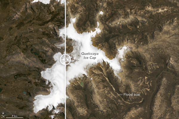
The Quelccaya Ice Cap, situated on a high-altitude plateau in Peru's Andes Mountains, is experiencing significant retreat due to climate change. This phenomenon is evident by comparing Landsat 5's Thematic Mapper (TM) image from September 3, 1988, to that of Landsat 8's Operational Land Imager (OLI) image taken on October 22, 2023, According to some estimates, the ice cap's area has reduced from approximately 58 square kilometers in 1988 to just over 40 square kilometers in 2023. These images also reveal an increase in meltwater lakes, once formed by the ice, that are now disconnected from it.
Such changes were already suspected before the Landsat era; since 1974, The Ohio State University's Earth Sciences Distinguished University Professor Lonnie Thompson and his team have been studying Quelccaya. They have documented the glacier's retreat, which averages about 14 meters annually.
Thompson's team has shared their findings with local authorities and indigenous communities. They have also conducted ice core drilling to analyze historical air temperature and atmospheric composition data. These cores provide insights into paleoclimate conditions. Thompson emphasizes the critical role of tropical glaciers in understanding global mean temperature changes and climate evolution, especially in regions where a significant portion of the global population resides.
Thompson predicts the complete disappearance of the Quelccaya Ice Cap by the end of the 21st century. If this occurs, the only evidence of its former existence will be the terrestrial and satellite images documenting its past grandeur above the Amazon Basin.
Visit NASA Earth Observatory for additional resources and to learn more about "Quelccaya Ice Cap Then and Now."
NASA Earth Observatory images by Wanmei Liang, using Landsat data from the U.S. Geological Survey.