Dyer Plateau
Antarctica
Overview
A cooperative glaciological-climatological ice core drilling program was conducted between 1988 and 1992 on the Dyer Plateau (70o40'16' S; 64o52'30'W; 2002 m a.s.l; MAT: -21oC). The program draws upon the expertise of scientists from the British Antarctic Survey, the University of Washington and The Ohio State University to establish a 480-year paleoenvironmental history of the Antarctic Peninsula region. In 1988/89 a geophysical program was initiated and two ice cores were drilled to a depth of 108 m at a location 6 km west of the divide. In 1989/90 two cores were recovered one meter apart on the crest of Dyer Plateau (Core 1 - 233.8 m and Core 2 - 235.2 m) and two 50-m cores were drilled 4 km east of the divide.
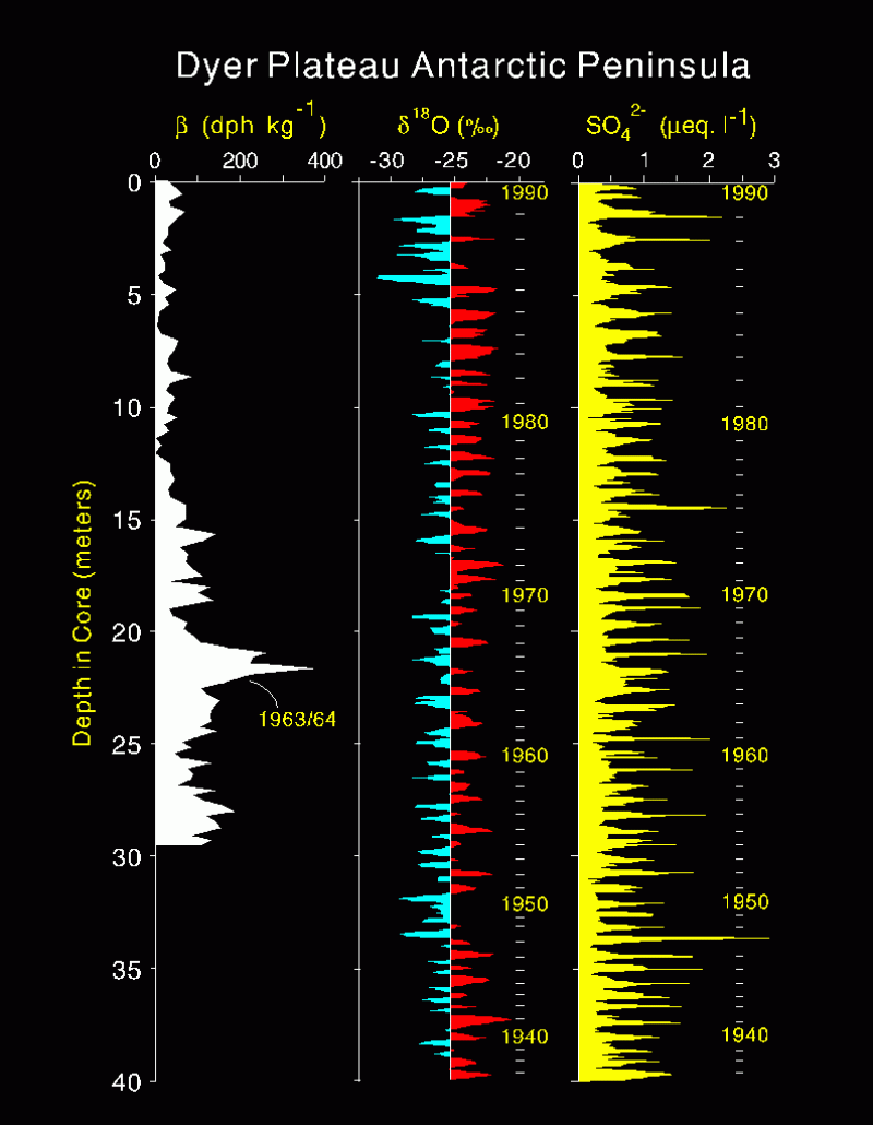
In 1989/90 the geophysical measurements were expanded to encompass the new core locations as well as potential future drill sites. The excellent seasonality in sulfate concentrations and oxygen isotopic ratios (shown in the figure) allowed us to date the core annually to A.D. 1505. Selected publications describing the Dyer records include:
Dai, J., L.G. Thompson, and E. Mosley-Thompson. A 495-year record of atmospheric chloride, nitrate, and sulfate: Results of chemical analysis of ice cores from Dyer Plateau, Antarctic Peninsula. Annals of Glaciology, 21, 182-188.
Raymond, C.F., B.R. Weertman, L.Thompson, E. Mosley-Thompson, D. Peel and R. Mulvaney. Geometry, motion and mass balance of Dyer Plateau, Antarctica. Journal of Glaciology, 42(142), 510-518.
Thompson, L.G., D.A. Peel, E. Mosley-Thompson, R. Mulvaney, J. Dai, P.-N. Lin, M.E. Davis, and C.F. Raymond. Climate since AD 1510 on Dyer Plateau, Antarctic Peninsula: evidence for recent climatic change. Annals of Glaciology, 20, 420 -426.